
Map of Highest Peak - Solution & Explanation
Problem Statement
You are given an integer matrix isWater of size m x n that represents a map of land and water cells.
- If
isWater[i][j] == 0, cell(i, j)is a land cell. - If
isWater[i][j] == 1, cell(i, j)is a water cell.
You must assign each cell a height in a way that follows these rules:
- The height of each cell must be non-negative.
- If the cell is a water cell, its height must be
0. - Any two adjacent cells must have an absolute height difference of at most
1. A cell is adjacent to another cell if the former is directly north, east, south, or west of the latter (i.e., their sides are touching).
Find an assignment of heights such that the maximum height in the matrix is maximized.
Return an integer matrix height of size m x n where height[i][j] is cell (i, j)'s height. If there are multiple solutions, return any of them.
Example 1:
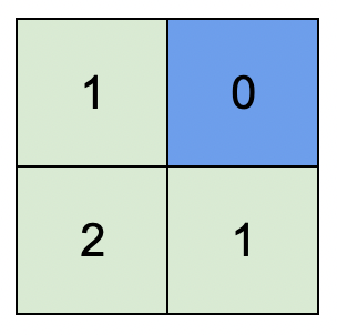
Input: isWater = [[0,1],[0,0]]
Output: [[1,0],[2,1]]
Explanation: The image shows the assigned heights of each cell.
The blue cell is the water cell, and the green cells are the land cells.
Example 2:
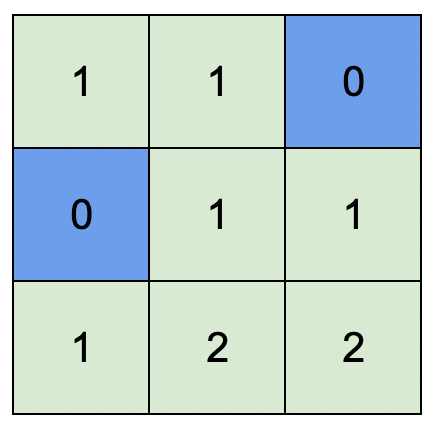
Input: isWater = [[0,0,1],[1,0,0],[0,0,0]]
Output: [[1,1,0],[0,1,1],[1,2,2]]
Explanation: A height of 2 is the maximum possible height of any assignment.
Any height assignment that has a maximum height of 2 while still meeting the rules will also be accepted.
Constraints:
m == isWater.lengthn == isWater[i].length1 <= m, n <= 1000isWater[i][j]is0or1.- There is at least one water cell.
Note: This question is the same as 542: https://leetcode.com/problems/01-matrix/
Approach Overview
Problem Overview: You receive a grid where 1 represents water and 0 represents land. Water cells must have height 0. Assign heights to land so adjacent cells differ by at most 1, while maximizing the overall peak height in the grid.
Approach 1: Brute Force BFS from Each Land Cell (O((m*n)^2) time, O(m*n) space)
A direct idea is to compute the distance from every land cell to the nearest water cell. For each land cell, run a BFS over the matrix until you encounter water. The distance to the closest water cell becomes the height of that land cell. This works because the maximum valid height is exactly the shortest distance to water under the "adjacent difference ≤ 1" constraint. However, running BFS for every cell leads to repeated exploration of the same grid regions, resulting in O((m*n)^2) time complexity. This approach demonstrates the core insight (distance from water) but is inefficient for large grids.
Approach 2: Multi-source Breadth-First Search (BFS) (O(m*n) time, O(m*n) space)
The key observation: a cell's height equals its shortest distance to any water cell. Instead of running BFS from every land cell, start BFS simultaneously from all water cells. Initialize a queue with every water position and assign them height 0. Then expand outward layer by layer using Breadth-First Search. Each time you visit an unassigned neighbor, set its height to the current cell's height plus one and push it into the queue.
This multi-source BFS naturally computes the shortest distance from water for every cell. BFS guarantees the first time you reach a cell is through the shortest path, so the assigned height is optimal. You traverse each cell at most once, giving O(m*n) time. The queue and height grid require O(m*n) space. The approach works well because grid movement forms an unweighted graph where BFS directly produces minimum distances.
The implementation uses a queue, four-direction traversal, and a result grid initialized to -1 for unvisited cells. Water cells start in the queue with height 0. As BFS expands, neighboring cells receive increasing heights that represent their distance from water. This pattern frequently appears in array grid problems involving distance propagation or wave expansion.
Recommended for interviews: Multi-source BFS is the expected solution. Interviewers want to see recognition that the height equals the shortest distance to water and that BFS can compute distances from multiple sources simultaneously. Mentioning the brute-force per-cell BFS first shows understanding of the distance relationship, while transitioning to multi-source BFS demonstrates optimization skills.
Approach 1: Approach 1: Multi-source Breadth-First Search (BFS)
This approach uses a multi-source BFS starting from all water cells. We initialize the height of all water cells to 0 and enqueue them. For each dequeued cell, we assign heights to unvisited adjacent cells by increasing the height by 1, and continue the BFS until all cells are visited. This ensures that adjacent height differences are at most 1.
The C solution initializes a queue data structure and begins the BFS from all water cells. Heights are adjusted as the BFS progresses, ensuring all cells maintain the required height difference constraint of at most 1 unit between adjacent cells. The solution handles all edge cases such as different matrix boundaries. The solution uses a single while loop to expand from each cell, ensuring optimal resource usage.
Complexity
Time Complexity: O(m * n), where m and n are dimensions of the matrix, as each cell is dequeued and enqueued at most once.
Space Complexity: O(m * n) for the height matrix and BFS queue.
Approach 2: Default Approach
Try this approach in the editor →Complexity Comparison
| Approach | Complexity |
|---|---|
| Approach 1: Multi-source Breadth-First Search (BFS) | Time Complexity: O(m * n), where m and n are dimensions of the matrix, as each cell is dequeued and enqueued at most once. |
| Default Approach | — |
Detailed Complexity Analysis
| Approach | Time | Space | When to Use |
|---|---|---|---|
| BFS from Each Land Cell | O((m*n)^2) | O(m*n) | Conceptual starting point to understand that height equals distance to nearest water |
| Multi-source BFS | O(m*n) | O(m*n) | Optimal solution for computing minimum distance from multiple sources in a grid |
Video Solution
Map of Highest Peak | Multi-Source BFS | Leetcode 1765 | Graph Concepts & Qns- 48 | codestorywithMIK • codestorywithMIK • 11,889 views views
Watch 9 more video solutions →Frequently Asked Questions
Is Map of Highest Peak easy or hard?
Map of Highest Peak Python/Java solution
How to solve Map of Highest Peak in O(n)?
What is the best approach for Map of Highest Peak?
Is Map of Highest Peak asked at Google/Amazon/Meta?
What data structure is used in Map of Highest Peak?
What is the time complexity of Map of Highest Peak?
Ready to solve this problem?
Practice Map of Highest Peak with our built-in code editor and test cases.
Practice on FleetCode